At full size, width="1024" height="704" go here
Back to Home Back to Virtual Menu Back to Travel Menu
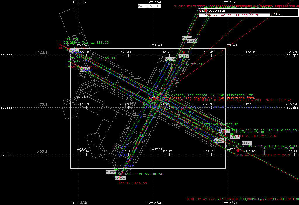
A. Imagine hovering over KSFO airport, at 'night', combining DAFIFT data with FlightGear/Peel data. You can see they match most excellently ...
At full size, width="1024" height="704" go here
This is the graphic output of my fgsd (FG Show Data) tool, set at a scale of 300 pixels per n. mile. DAFIF data has 'blue-lights' around its runways, 'green' ILS and navaids, with matching coloured text. While the FG data, runways are 'green', ILS/NavAid 'red', and taxiways in 'gray', etc. The white rectangle is a border formed from the DAFIFT runways.
Those familiar with a 'map' of San Francisco International airport will almost be able to 'recognise' where the actual roads would be. Some may be able to 'see' the car rental buses trundling around, although they move very slowly at this late hour :-)
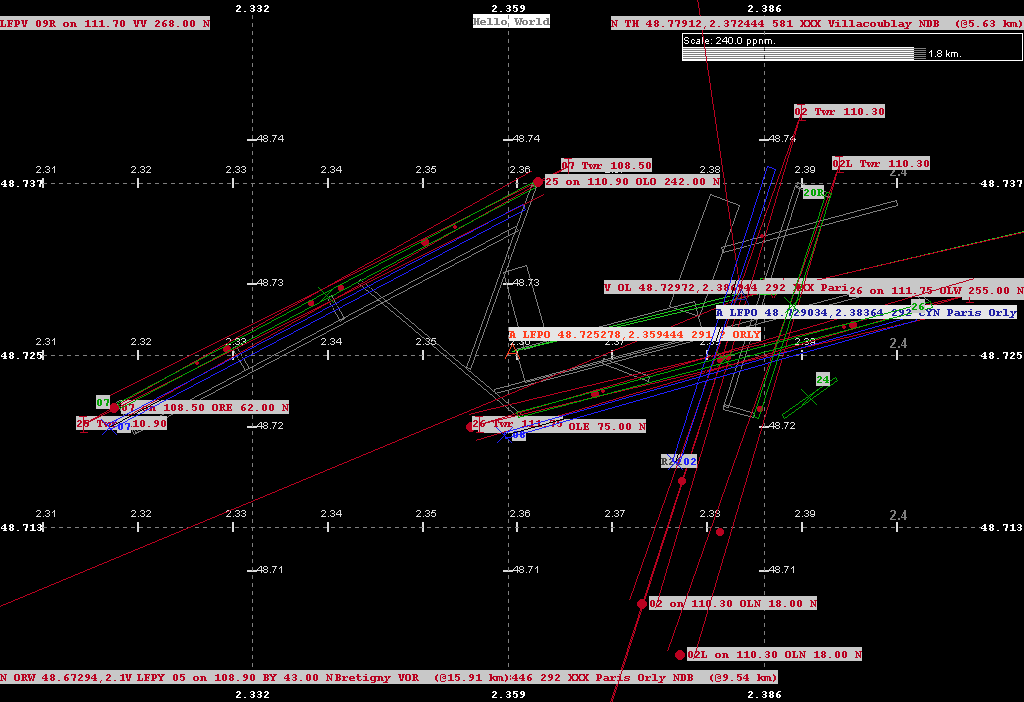
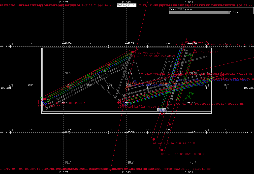
B. Then you are 'transported' instantly, hovering over LFPO airport, at 'night', again combining DAFIFT data with FlightGear/Peel data. You can 'see' a little difference.
At full size, width="1024" height="704" go here
You can 'see' the FG (green) runways are about 100 m to the EW'ish of the DAFIFT (blue) runways. Of course all the beautiful taxiways line up well with the FG runways. Would there be a way to 'programmatically' lock and drag the FG r/w+t/w's onto the DAFIFT co-ordinates, and write out a new FG database line? Would that work?
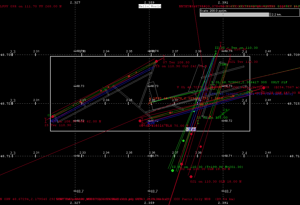
Dropping the scale to 150 ppnm maybe give a better (at least later) view -
Also, in this particular case the FG 02L ILS is repeated as 02, and the repeat entry lines up more closely with the DAFIFT. It look like someone applied a manual patch to fix the 02 ILS, but any radio tuneable device would be very confused by two transmission towers on the same frequency. There would only be a small complaint from the user's about 07/28 and 08/26 runways because of their large EW component, but the fix was needed on 02 due to a separation of about 0.04 degree of longitude. Maybe DAFIFT has been 'updated' since the 'import' into the FG data. Do not know exactly :-/
The fantastic thing about the FG runways is that they also include the small 24 runway not in DAFIFT. On the FG development board I read recently that there are a lot of airports, runways, taxiways that are not in DAFIFT, and that is born out by some raw number. My data is about a week old (circa mid-Feb, 2003), although I read and saw some subsequent CVS updates of the FG zip/tar files, but have not unpacked these yet -
On load fgsd maps [D:/FG/Dafift/ARPT/ARPT.TXT] file, 1221169 bytes, 08/01/03 13:14, [D:/FG/Dafift/ARPT/RWY.TXT] file, 3110447 bytes, 06/01/03 09:03, [D:/FG/Dafift/ARPT/ILS.TXT] file, 1186450 bytes, 06/01/03 09:03, [D:/FG/Dafift/NAV/NAV.TXT] file, 1574327 bytes, 06/01/03 09:04, [D:/FG/Dafift/WPT/WPT.TXT] file, 8512593 bytes, 08/01/03 11:25, [D:\FG\SD\default.apt] file, 3872349 bytes, 30/12/02 21:22, [D:\FG\SD\default.nav] file, 692808 bytes, 06/02/03 15:09, [D:\FG\SD\default.ils] file, 420873 bytes, 24/01/03 18:31, [D:\FG\SD\default.fix] file, 485830 bytes, 20/12/00 15:56.
Then some counts - D:/FG/Dafift/ARPT/ARPT.TXT has 22 cols (38 mx.), 9896 lines/items, D:/FG/Dafift/ARPT/RWY.TXT has 50 cols (12 mx.), 13782 lines/items,DAFIFT Ils lines 9415, as of 06/01/03 09:03, D:/FG/Dafift/NAV/NAV.TXT has 31 cols (30 mx.), 11193 lines/items, DAFIFT Wpt lines 72550, as of 08/01/03 11:25, Got 9974 FGFS Navs, D=101, N=6677, V=3196, 2238 FGFS Ils objects, Summary: Of 2238 FGFS Ils objects, L=237, I=1949, M=3, S=26, D=23 (0), FG Fix lines 16192, as of 20/12/00 15:56, Airports 17455, Runways 21424, Sea 368, Helo 14.
Or, about
DAIFIF has 10000 airports, 14000 runways, 10000 ils, 11000
navaids, and 72000 way points, and
FG has 17000 airports, 21000 runways, 2000 ils, 10000 navaids, and 16000 fixes.
One interesting thing about the ils count is that the FG ils is a
'collection' of items in one record, while DAFIFT has multiple records
per runway, so they are probably not too different counts really.
Of course, the FG files come from Peel, so I next downloaded AptNav200302.zip from - Robin's download page here. This, as you can read, is the data used in X-Plane, and has been recently (2003/02) updated from the DAFIF data, and the taxiways fully alligned.
This is a relatively calm view of KSFO using all three sets of data, and same world coords-to-pixel (maybe bad!) math for allignment.
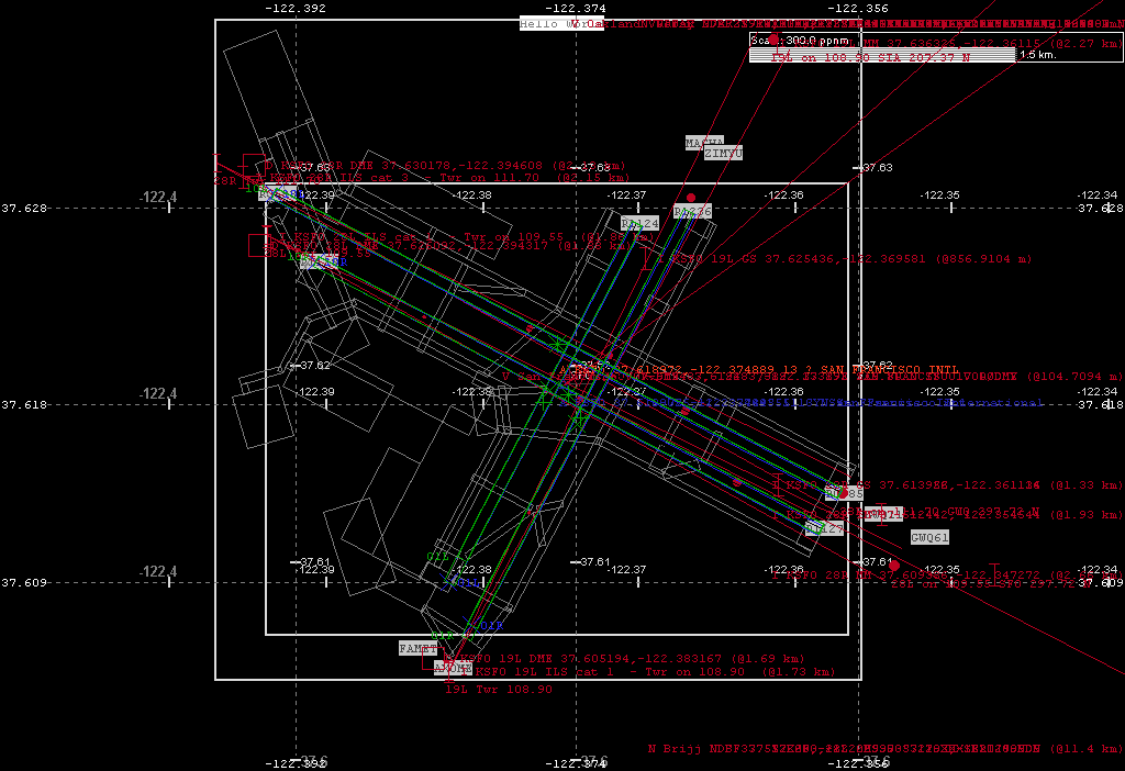
Although, with a 'magnifying" glass, I can change the pixels per
n.miles in my 'viewer', runway FG 01L is 'shorter than DAIFIT/Peel O1L,
and the taxiway 01L crossing 01R to the SE if off the end of the FG rwy.
But this may be due to the fact that the CENTER coordinate are NOT the
same.
If a FG 'green' diag.cross is painted on the X-Plane 'green' horiz.cross, it forms an asteric, as they do on the 28L/R pair, then the data is the same, but we can see both type of 'crosses' on the 01L/R pair. DAFIFT given the center of the end of the runway, and my rectangle is formed by turning 90, march 1/2 width, turn 180 and march 1 width, turn -90, march length, -90, etc.
Using the 'centers' given in FG and Peel, I march, on heading for 1/2 length, turn 90 for 1/2 width, turn 90 for length, etc. So this 'varied' form of getting the 'rectangle' to describe can also be the cause of some 'misalignment' between the databases.
But even with a cvs update of the FG (fgfsbase) some of this DAFIF/Peel has not yet been 'imported/updated', or simply not ther yet, and this repeat of LFPO at 150 ppnm shows -
On 25/07 the DAFIFT/Peel agree 100%, eg DAFIF 'blue' runways are almost exactly overlayed with the Peel 'green' runways, while the FG 'green' runway misses by some. As stated, I am sure this is more a question of 'time' before 'all' are aligned, especially since we are dealing with rather 'solid' man-made objects, whose 'real' world position can be rather precisely determined today with lovely things like GPS instruments.
This is a vast store of information.
Yippee! It exists!! Databases, publicly, freely available that document
our 'flight' achievements. I hope I can just do something to keep and improve them ...
This is exploration 'work-in-progress' ... stay tuned, but DO NOT hold your breath :-))
On to page 2. Here I try to 'view' the 3 data sets together. That is DAFIFT, FlightGear and X-Plane/Peel.
To read more on the precursor to fgsd, go Flight Simulator File Viewer
* Try More * Back to Home * Back to Virtual Menu * Back to Travel Menu *